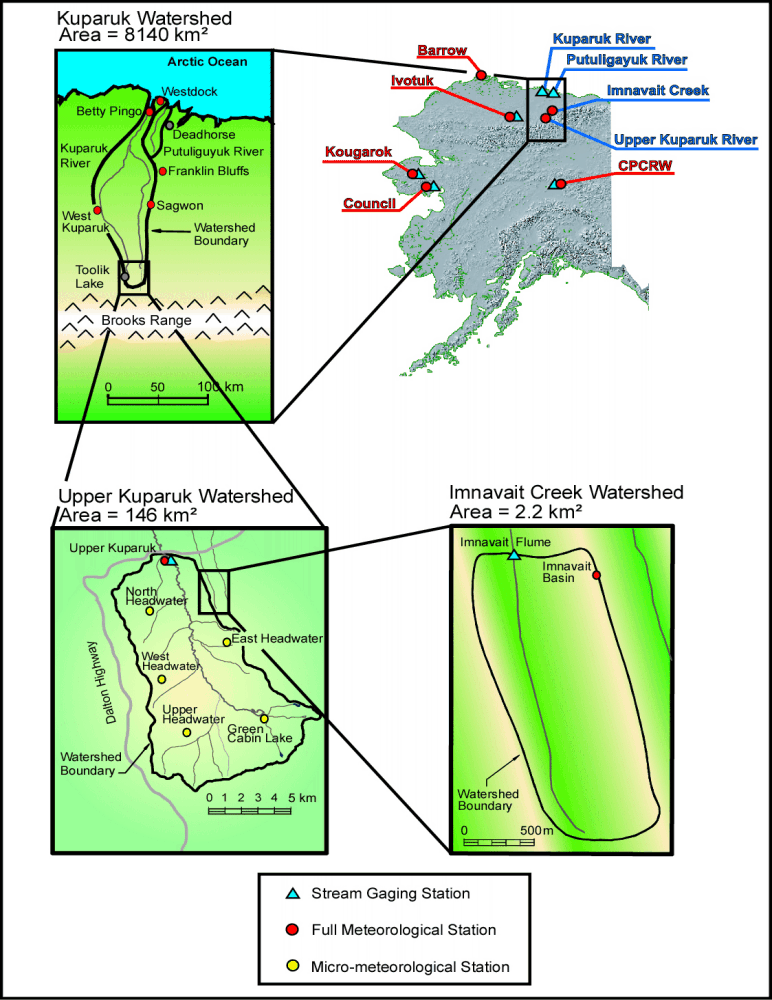
WERC- North Slope Hydrology Research Projects

Kuparuk River Watershed Studies

UAF, Water and Environmental Research Center logo
Site Map:
Imnavait Watershed Sites  
Graphic bullet to indicate selection itemSite Information Graphic bullet to indicate selection itemBasin
Graphic bullet to indicate selection itemRidge
Graphic bullet to indicate selection itemValley
Graphic bullet to indicate selection itemFlume
Graphic bullet to indicate selection itemInstrumentation  
Graphic bullet to indicate selection itemImages

Upper Kuparuk Watershed Sites  
Graphic bullet to indicate selection itemSite Information
Graphic bullet to indicate selection itemU.K. Met
Graphic bullet to indicate selection itemU.K. River
Graphic bullet to indicate selection itemNorth Headwater
Graphic bullet to indicate selection itemEast Headwater
Graphic bullet to indicate selection itemWest Headwater
Graphic bullet to indicate selection itemUpper Headwater
Graphic bullet to indicate selection itemGreen Cabin Lake
Graphic bullet to indicate selection itemInstrumentation 
Graphic bullet to indicate selection itemImages

Western Kuparuk Sites  
Graphic bullet to indicate selection itemSite Information
Graphic bullet to indicate selection itemWest Kuparuk
Graphic bullet to indicate selection itemInstrumentation  
Graphic bullet to indicate selection itemImages

Eastern Kuparuk Sites  
Graphic bullet to indicate selection itemSite Information
Graphic bullet to indicate selection itemSagwon
Graphic bullet to indicate selection itemFranklin Bluffs
Graphic bullet to indicate selection itemInstrumentation  
Graphic bullet to indicate selection itemImages

Coastal Plain Sites  
Graphic bullet to indicate selection itemSite Information
Graphic bullet to indicate selection itemBetty Pingo
Graphic bullet to indicate selection itemWest Dock
Graphic bullet to indicate selection itemPutuligayuk River
Graphic bullet to indicate selection itemInstrumentation  
Graphic bullet to indicate selection itemImages

General Info  
Graphic bullet to indicate selection itemNorth Slope Hydrology
Graphic bullet to indicate selection item Main Page Graphic bullet to indicate selection itemIntroduction
Graphic bullet to indicate selection itemReferences
Graphic bullet to indicate selection itemSite Usage Statistics
Graphic bullet to indicate selection itemWERC Home
Graphic bullet to indicate selection itemRelated Links
Welcome to The University of Alaska Fairbanks, Water and Environmental Research Center (WERC) North Slope Hydrology Research Projects page. This page provides access to hydrology and environmental climate data from research sites spanning from the Northern foothills of the Brooks Range to the Coastal Plain of Alaska, near Prudhoe Bay. Most sites are within the Kuparuk River watershed. This material is based upon work supported by the National Science Foundation under Grants No. OPP-9318535, OPP-9214927 and OPP-9814984. Any opinions, findings,
conclusions, or recommendations expressed in the material are those of the author(s) and do not necessarily reflect the views of the National Science Foundation.

Near-Real-Time Data Map

map with location of hydrologic monitoring sites in the context of the entire state of Alaska and the Kuparuk River watershed - 44315 Bytes
Click here to view a higher resolution GIF Image (200 KB)
Introduction References Relevant Links
Upper Kuparuk sites Eastern Kuparuk sites Western Kuparuk sites
Imnavait sites Coastal Plain sites Watershed Comparisons

1985-2001 North Slope
Snow Survey Data (xls files)

SnowSurveys1985
SnowSurveys1986
SnowSurveys1987
SnowSurveys1988
SnowSurveys1989
SnowSurveys1990
SnowSurveys1991
SnowSurveys1992
SnowSurveys1993
SnowSurveys1994
SnowSurveys1995
SnowSurveys1996
SnowSurveys1997
SnowSurveys1999
SnowSurveys2000A
SnowSurveys2000B
SnowSurveys2001A
SnowSurveys2001B
SnowSurveys2002
ImnavaitSnowAblation85-00
Complete North Slope Snow
Survey Data (zip file)

2001-current North Slope
Snow Survey Data (xls files)

Combined Snow Data 1996-2005
SnowSurveys2006 (zip file)
SnowSurveys2007 (zip file)
SnowSurveys2008 (zip file)
SnowSurveys2009 (zip file)
SnowSurveys2010 (zip file)
SnowSurveys2011 (zip file)

North Slope Distributed Data (xls files)

DistributedKapaurkApril1998
NorthSlopeDistributed93-99
Complete North Slope
Distributed Data (zip file)
Metadata Report (Sensor/Data Information)
(last updated 2008)
Metadata Report (MS Word file)
Average Monthly Temperature
for North Slope Sites (last updated 1996)
Average Monthy Temperature (csv file)


Return to Main WERC page
If you have any questions or comments about this project, contact:

Douglas L. Kane
(ffdlk@uaf.edu)
Tel: (907) 474-7808
Larry D. Hinzman
(ffldh@uaf.edu)
Tel: (907) 474-7331
All At:
Water and Environmental Research Center
University of Alaska Fairbanks
Fairbanks, Alaska 99775
Fax: (907) 474-7979


These pages are best viewed with Netscape Ver.2+, or Internet Explorer Ver.3+

URL: http://ine.uaf.edu/werc/projects/NorthSlope/northslope.html

valid-html40.gif - 906 Bytes approved.gif - 2420 Bytes