WERC- North Slope Hydrology Research Projects

Imnavait Watershed Sites Information

UAF, Water and Environmental Research Center logo
Site Map:
Imnavait Watershed Sites  
Graphic bullet to indicate selection itemSite Information Graphic bullet to indicate selection itemBasin
Graphic bullet to indicate selection itemRidge
Graphic bullet to indicate selection itemValley
Graphic bullet to indicate selection itemFlume
Graphic bullet to indicate selection itemInstrumentation  
Graphic bullet to indicate selection itemImages

Upper Kuparuk Watershed Sites  
Graphic bullet to indicate selection itemSite Information
Graphic bullet to indicate selection itemU.K. Met
Graphic bullet to indicate selection itemU.K. River
Graphic bullet to indicate selection itemNorth Headwater
Graphic bullet to indicate selection itemEast Headwater
Graphic bullet to indicate selection itemWest Headwater
Graphic bullet to indicate selection itemUpper Headwater
Graphic bullet to indicate selection itemGreen Cabin Lake
Graphic bullet to indicate selection itemInstrumentation 
Graphic bullet to indicate selection itemImages

Western Kuparuk Sites  
Graphic bullet to indicate selection itemSite Information
Graphic bullet to indicate selection itemWest Kuparuk
Graphic bullet to indicate selection itemInstrumentation  
Graphic bullet to indicate selection itemImages

Eastern Kuparuk Sites  
Graphic bullet to indicate selection itemSite Information
Graphic bullet to indicate selection itemSagwon
Graphic bullet to indicate selection itemFranklin Bluffs
Graphic bullet to indicate selection itemInstrumentation  
Graphic bullet to indicate selection itemImages

Coastal Plain Sites  
Graphic bullet to indicate selection itemSite Information
Graphic bullet to indicate selection itemBetty Pingo
Graphic bullet to indicate selection itemWest Dock
Graphic bullet to indicate selection itemPutuligayuk River
Graphic bullet to indicate selection itemInstrumentation  
Graphic bullet to indicate selection itemImages

General Info  
Graphic bullet to indicate selection itemNorth Slope Hydrology
Graphic bullet to indicate selection item Main Page Graphic bullet to indicate selection itemIntroduction
Graphic bullet to indicate selection itemReferences
Graphic bullet to indicate selection itemSite Usage Statistics
Graphic bullet to indicate selection itemWERC Home
Graphic bullet to indicate selection itemRelated Links
Photo of Imanavait Creek, aerial view - 29440 Bytes
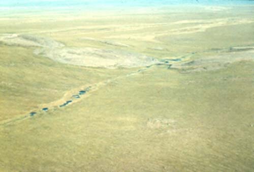
PHOTO: Larry Hinzman, WERC

The Imnavait Creek watershed is located on the North Slope of Alaska, at the foothills of the Brooks Range (68o37'N, 149o19'W). Imnavait Creek parallels the Upper Kuparuk basin and enters the Kuparuk River 12 km north of the Upper Kuparuk gauging station. This small watershed at the headwaters of the Kuparuk River has been monitored since 1985. Imnavait creek is a first order stream on the 1:63,360 USGS topographic map. Flows at Imnavait creek persist throughout the summer months, but during the late winter months flow is practically non-existent. The stream is beaded, meaning that the channel connects numerous interspersed small ponds. The ponds formed when massive ground ice melted due to some past thermal disturbance. These ponds are on the order of 2 m deep and a few meters in length and width (Kane et al. 2000).

The mineral soils in this area are cold, wet, poorly drained silt loams with a high organic content and include many glacial erratics of various sizes. The mineral soils are covered by a peaty layer, and are classified as Histic Pergelic Cryaquepts (Rieger et al., 1979). The vegetation is mostly water tolerant plants such as tussock sedges and mosses, but there are also lichens and shrubs such as willows, alder and dwarf birch. More complete descriptions of tundra vegetation have been published (Brown and Berg, 1980; Walker et al., 1989). The area was glaciated during the Pleistocene and is underlain by continuous permafrost. The maximum depth of soil thawed above the permafrost averaged 53 cm between 1992 and 1999 (Brown and Hinkel, 2000).

The meteorological, hydrological, and soil data archived here represents a continuous record of the Imnavait watershed site since 1985. Four monitoring stations were established for collection of such data:

  • Imnavait Basin (IB)
  • Imnavait Ridge (IR)
  • Imnavait Valley (IV)
  • Imnavait Flume (IH)

Imnavait Creek has a H-flume with water level recorder and pressure transducer to aid in flow measurement estimates. A complete meteorological station is located at the Imnavait Basin station. Variables measured at this met station are wind speed, relative humidity and air temperature at three elevations (with the maximum at 10 m). Wind direction, rainfall and soil temperatures are also measured. Incoming and outgoing long and short wave radiation are measured from before snowmelt until freeze-up. The water equivalent of the snowpack is measured late each spring at numerous locations over the basin just before melt begins (Kane et al. 2000).


Brown, J. and R.L. Berg, (eds.). 1980. Environmental engineering and ecological baseline investigations along the Yukon River-Prudhoe Bay Haul Road. U.S. Army CRREL Report 80-19. 187 p.

Brown J. and K. Hinkel, 2000. Circumpolar Active Layer Monitoring (CALM) Network. http://www.geography.uc.edu/~kenhinke/CALM/sites.html.

Kane, D.L., Hinzman, L.D., McNamara, J.P., Zhang, Z., and Benson, C.S. (2000)An Overview of a Nested Watershed Study in Arctic Alaska, Nordic Hydrology, Vol. 31 (4/5), 245-266.

Rieger, S., D.B. Schoephorster, and C.E. Furbush. 1979. Exploratory soil survey of Alaska. U.S.D.A. Soil Conservation Service. Washington D.C. 213 p.

Walker, M.D., D.A. Walker and K.R. Everett. 1989. Wetland soils and vegetation, Arctic Foothills, Alaska. U.S. Fish and Wildlife Service. Biological Report 89(7), 89 p.

Imnavait Basin
data
Updated 02/02
Imnavait Ridge
data
Updated 02/02
Imnavait Valley
data
Updated 02/02
Imnavait Flume
data
Updated 02/02
Instrumentation
Information
Updated 02/02
Imnavait Images
Updated 02/02
Watershed
Comparisons
Updated 02/02
--


Return to Main WERC page
If you have any questions or comments about this project, contact:

Larry D. Hinzman
(ffldh@uaf.edu)
Tel: (907) 474-7331
Douglas L. Kane
(ffdlk@uaf.edu)
Tel: (907) 474-7808
All At:
Water and Environmental Research Center
University of Alaska Fairbanks
Fairbanks, Alaska 99775
Fax: (907) 474-7979


These pages are best viewed with Netscape Ver.2+, or Internet Explorer Ver.3+

URL: http://ine.uaf.edu/werc/projects/NorthSlope/imnavait/imnavait.html