WERC- North Slope Hydrology Research Projects

Coastal Plain Sites Information

UAF, Water and Environmental Research Center logo
Site Map:
Imnavait Watershed Sites  
Graphic bullet to indicate selection itemSite Information Graphic bullet to indicate selection itemBasin
Graphic bullet to indicate selection itemRidge
Graphic bullet to indicate selection itemValley
Graphic bullet to indicate selection itemFlume
Graphic bullet to indicate selection itemInstrumentation  
Graphic bullet to indicate selection itemImages

Upper Kuparuk Watershed Sites  
Graphic bullet to indicate selection itemSite Information
Graphic bullet to indicate selection itemU.K. Met
Graphic bullet to indicate selection itemU.K. River
Graphic bullet to indicate selection itemNorth Headwater
Graphic bullet to indicate selection itemEast Headwater
Graphic bullet to indicate selection itemWest Headwater
Graphic bullet to indicate selection itemUpper Headwater
Graphic bullet to indicate selection itemGreen Cabin Lake
Graphic bullet to indicate selection itemInstrumentation 
Graphic bullet to indicate selection itemImages

Western Kuparuk Sites  
Graphic bullet to indicate selection itemSite Information
Graphic bullet to indicate selection itemWest Kuparuk
Graphic bullet to indicate selection itemInstrumentation  
Graphic bullet to indicate selection itemImages

Eastern Kuparuk Sites  
Graphic bullet to indicate selection itemSite Information
Graphic bullet to indicate selection itemSagwon
Graphic bullet to indicate selection itemFranklin Bluffs
Graphic bullet to indicate selection itemInstrumentation  
Graphic bullet to indicate selection itemImages

Coastal Plain Sites  
Graphic bullet to indicate selection itemSite Information
Graphic bullet to indicate selection itemBetty Pingo
Graphic bullet to indicate selection itemWest Dock
Graphic bullet to indicate selection itemPutuligayuk River
Graphic bullet to indicate selection itemInstrumentation  
Graphic bullet to indicate selection itemImages

General Info  
Graphic bullet to indicate selection itemNorth Slope Hydrology
Graphic bullet to indicate selection item Main Page Graphic bullet to indicate selection itemIntroduction
Graphic bullet to indicate selection itemReferences
Graphic bullet to indicate selection itemSite Usage Statistics
Graphic bullet to indicate selection itemWERC Home
Graphic bullet to indicate selection itemRelated Links
Image of wetland and upland areas at the Betty Pingo site - 16955 Bytes
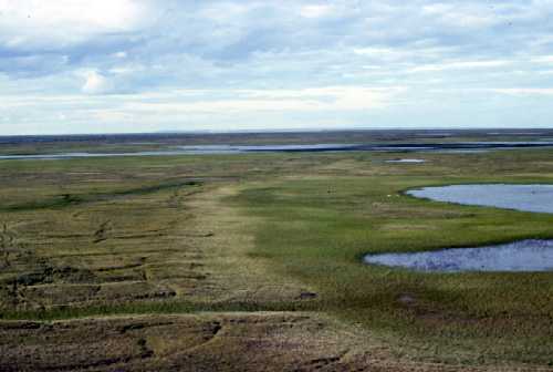
PHOTO: Larry Hinzman, WERC

The northern-most monitoring sites on the Kuparuk Watershed Study are located on the Arctic Coastal Plain of Alaska (approx. 70o 16'N, 148o 53'W). This area is a vast expanse of flat topography dominated by wetlands, ponds, and lakes. Numerous permafrost features also exist like high and low centered polygons, pingos, strangmoor ridges, and hummocky ground (Kane et. al 2000). The vegetation of this area varies from tussock tundra in higher, drier ground to sedges and grasses in wetter areas.

The meteorological, hydrological and soil data archived here represents a continuous record of the Coastal Plain research sites since May 1994. Three monitoring stations were established for collection of such data:

  • Betty Pingo (Established in May 1994)
  • West Dock (Established in 1995)
  • Putuligayuk River (Established in 1999)

The Betty Pingo site is located in a small wetland watershed (8.15 ha) on the southern edge of the Prudhoe Bay oil field (Mendez et al. 1998). The site is at an elevation of about 12 meters. The vegetation consists of wet sedge tundra and forb tundra. The soils are organic overlying layers of fine sand and silts. The 10 meter tower was established in a wetland area, however nearby dryer areas were also equipped with soil thermistors and net radiation instrumentation. The maximum depth of soil thawed above the permafrost averaged 55 cm between 1993 and 1999 (Brown and Hinkel, 2000). The West Dock monitoring station is located close to the arctic ocean, on the west side of Prudhoe Bay. This site is at the edge of a marshy, drained lake basin.

Parallel to the east of the Kuparuk River on the coastal plain is the Putuligayuk River. This catchment (471 km2) is unique in that the watershed is totally confined to the low gradient coastal plain. It is dominated by wetlands, ponds and wind-oriented lakes. The USGS monitored this stream for 15 years, from 1970 to 1986 (data for 1980 and 1981 missing). There are no corresponding precipitation data to complement the runoff data. We have only recently re-initiated monitoring of this watershed (Kane et al. 2000).

The Putuligayuk River site is mainly a stream gaging station. However, complete meteorological stations are located at the Betty Pingo and West Dock sites. Variables measured at these sites are wind speed, relative humidity and air temperature at three elevations (with the maximum at 10 m). Wind direction, rainfall and soil temperatures are also measured. Incoming and outgoing long and short wave radiation are measured from before snowmelt until freeze-up. Surface drainage from the Betty Pingo study area is quantified by means of a V-notch weir. At the Betty site, soil moisture is measured automatically for several profiles at three to four depths with time domain reflectometry (TDR), several times per day. The water equivalent of the snowpack is measured late each spring at these sites just before melt begins (Kane et al. 2000).


Brown J. and K. Hinkel, 2000. Circumpolar Active Layer Monitoring (CALM) Network. http://www.geography.uc.edu/~kenhinke/CALM/sites.html.

Kane, D.L., Hinzman, L.D., McNamara, J.P., Zhang, Z., and Benson, C.S. (2000). An Overview of a Nested Watershed Study in Arctic Alaska, Nordic Hydrology, Vol. 31 (4/5), 245-266.

Mendez, J., Hinzman, L.D., and Kane, D.L.(1998). Evapotranspiration from a Wetland Complex on the Arctic Coastal Plain of Alaska, Nordic Hydrology, Vol. 29 (4/5), 303-330.

Betty Pingo
data
Updated 01/02
West Dock
data
Updated 01/02
Putuligayuk River
data
Updated 01/02
Instrumentation
Information
Updated 01/02
Coastal Plain Images
Updated 01/02
Watershed
Comparisons
Updated 01/02


Return to Main WERC page
If you have any questions or comments about this project, contact:

Larry D. Hinzman
(ffldh@uaf.edu)
Tel: (907) 474-7331
Douglas L. Kane
(ffdlk@uaf.edu)
Tel: (907) 474-7808
All At:
Water and Environmental Research Center
University of Alaska Fairbanks
Fairbanks, Alaska 99775
Fax: (907) 474-7979


These pages are best viewed with Netscape Ver.2+, or Internet Explorer Ver.3+

URL: http://ine.uaf.edu/werc/projects/NorthSlope/coastal_plain/coastal_plain.html