Basin Summaries
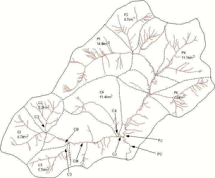
| Physical and hydrologic characteristics of the Caribou-Poker Creeks Research Watershed. (After Lotspeich and Slaughter 1981). Tributaries of Poker Creek are designated with a P, and tributaries fo Caribou Creek are designated with a C. Links are provided to the site description database for those basins that have ongoing studies. If there is no link, then the basin is not currently being used. | ||||||||||
| Basin | Area (km2) | Aspect | Elevation m | Total stream length (km) | Drainange Density (km/km) | Area below 305 m (%) | Area between 305 and 488 m (%) | Area between 488 and 640 m (%) | Area above 640 m (%) | Area underlain by permafrost (%) |
| PC | 101.5 | -- | 226-826 | 48.4 | 0.77 | 8.2 | 34.2 | 32.5 | 24.1 | 30.7 |
| PJ | 59.8 | S | 226-826 | 29.6 | 0.80 | 7.8 | 31.3 | 33.5 | 25.9 | 30.5 |
| CJ | 41.7 | E | 226-770 | 19.0 | 0.73 | 9.8 | 39.9 | 23.8 | 21.5 | 28.0 |
| C1 | 6.7 | E | 325-735 | 3.5 | 0.86 | 0.0 | 40.8 | 43.4 | 15.8 | 26.1 |
| CB | E | |||||||||
| C2 | 5.2 | S | 323-738 | 2.2 | 0.70 | 0.0 | 29.0 | 38.0 | 33.0 | 3.5 |
| C3 | 5.7 | NE | 274-770 | 2.6 | 0.73 | 0.1 | 39.5 | 51.4 | 9.1 | 53.2 |
| C4 | 11.4 | SSE | 226-686 | 5.0 | 0.70 | 5.9 | 27.3 | 50.9 | 15.9 | 18.8 |
| CM | 23.8 | E | 256-770 | 11.1 | 0.93 | 3.0 | 41.0 | 39.0 | 17.0 | 23.8 |
| C above gage | 4.9 | SE | 256-640 | 2.8 | -- | 14.0 | 58.5 | 21.5 | 6.0 | 14.5 |
| P1 | 14.8 | ENE | 360-773 | 5.8 | 0.63 | 0.0 | 15.8 | 34.3 | 52.8 | 37.8 |
| P2 | 6.7 | S | 360-826 | 4.0 | 0.96 | 0.0 | 10.0 | 16.9 | 62.0 | 6.9 |
| P4 | 11.1 | SW | 293-825 | 7.7 | 1.11 | 0.1 | 41.4 | 30.5 | 27.5 | 14.2 |
| P6 | 7.0 | NW | 271-735 | 3.9 | 0.89 | 0.2 | 37.1 | 42.7 | 18.5 | 17.8 |