Exploring hydrology-permafrost-methane processes within the lake-to-watershed system
The Goldstream Valley Watershed Project will host a community meeting on Tuesday, May 17, 2016 at 7PM at the Ken Kunkel Community Center.
Researchers will present preliminary results from the permafrost survey that was conducted via helicopter earlier this year. In addition, community members who participated in the snow survey will have an opportunity to share their notes.
When?
Tuesday, May 17, 2016 at 7PM
Where?
Ken Kunkel Community Center, 2645 Goldstream Rd, Fairbanks
Now that the helicopter part of the survey is completed, Goldstream researchers are in the midst of processing the obtained data. In order to understand what the raw data means, the resistivity values are compared to known subsurface materials.
Even though there is still a lot of processing to do, some areas are already understood quite well and preliminary results of these will be presented at the May 17 community meeting.
The data set is large and won't be available in its entirety for another few years. However, once it has been fully processed into geologic maps, it will become freely available at the DGGS web page for anyone to access.
Find out more about the Goldstream project and the ongoing aerial survey in this March 7 News Miner article.
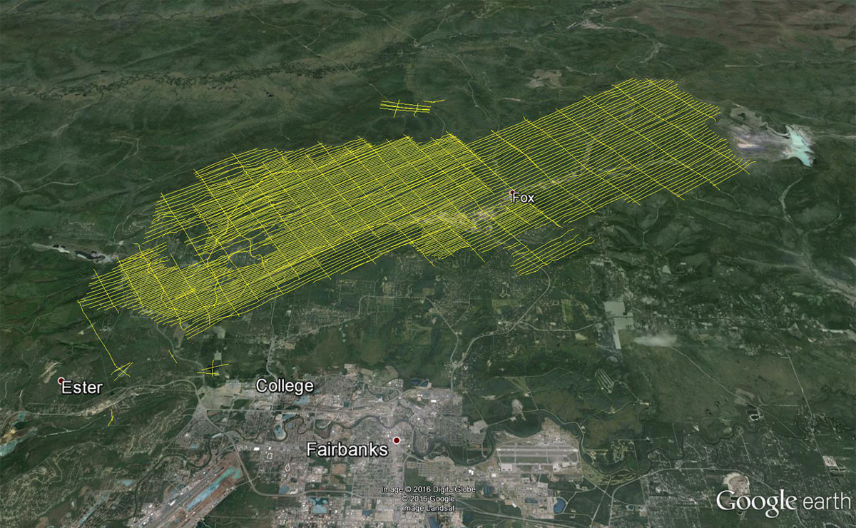
This spring, the Alaska Department of Natural Resources’ Division of Geological & Geophysical Surveys (DGGS), in collaboration with the University of Alaska Fairbanks, is mapping permafrost distribution in the Goldstream Valley watershed.
Data collection will start February 23 and last for about two to four weeks. The survey will be completed by March 14, 2016.
Data will be collected using a specialized geophysical instrument (bird) towed on a 100-foot-long line from a small civilian helicopter. During data collection the 25-foot-long bird will be flown about 100 feet above the ground.
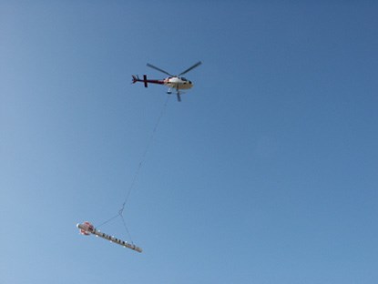
Photo provided by DGGS.
DGGS awarded a contract to the geophysical company CGG of Canada and their subcontractor Soloy Helicopters of Wasilla.
Mapping will be performed using airborne electromagnetic (AEM) data. A small magnetic field is generated in the air which in turn generates small electrical currents as it penetrates the ground. Variations in the ground “resist” the current and can be measured as electrical resistivity.
CGG’s RESOLVE system is designed to map the spatial distribution of electrical resistivity of a landscape. All these data points in the ground will be used to help interpret where the ground is frozen and where it is not.
This system is a low power system that does not pose a health risk and will not impact your communication devices.
DGGS and their contractors are working closely with Fairbanks FAA staff to ensure public safety while the helicopter is flying. The FAA recommends that you remain clear of the helicopter’s path of flight. The helicopter will not fly directly over your house and if the helicopter is over your property it is best to remain indoors.
The final 3D map of permafrost distribution in the valley will be used by our interdisciplinary research team to develop conceptual and computer models for groundwater and surface water flow and to study the effects of a warming climate on permafrost.
Trapped greenhouse gasses in and underneath permafrost are expected to be released to the atmosphere when permafrost thaws. This study will address the quantity and timing of the release of those gasses with the ultimate goal of better understanding the relationship between climate warming and greenhouse gas release from an area of discontinuous permafrost.