During the Illinoian and Wisconsin glaciations, large amounts of glacial silt were deposited in the braided river channels of the Yukon and Tanana Rivers to the north and south of the Yukon-Tanana Uplands. Southerly winds transported this silt and deposited it in the uplands as loess. The thickest loess deposits in the area are on south-facing slopes and in valley bottoms immediately adjacent to the Tanana River. In CPCRW, there is a but a thin cap of loess on most sites.
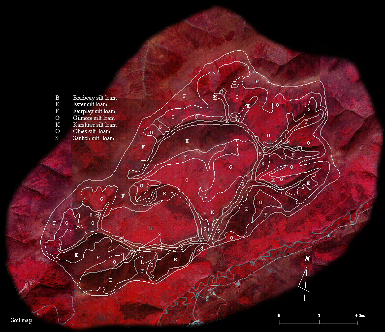
Rieger et al. (1972) identified seven soils series in the
reasearch watershed (Table 1, Figure
1). These seven series can be grouped into two general
categories: permafrost-dominated soils that are poorly drained
and have high moisture and ice contents, and well-drained,
permafrost-free soils. See Permafrost
page for more information.
| Table 1. Description of soil types found in Caribou-Poker Creeks Research Watershed. | ||||||
| Soil Series | USDA Texture | Drainage | Permafrost | Location | % Area | |
| Bradway | Stratified silt loam and loamy sand | poorly drained | shallow | flood plain | 1.9 | |
| Ester | Silt loam | poorly drained | shallow | steep north-facing slopes | 19.1 | |
| Fairplay | Silt loam and gravelly silt loam | mod. well drained | none | high ridges above tree line | 21.9 | |
| Gilmore | Silt loam, gravelly silt loam, and very gravelly silt loam | well drained | none | south-facing slopes | 11.5 | |
| Karshner | Stratified silt loam, silt loam, very gravelly silt loam, and very gravelly loamy sand | poorly drained | shallow | narrow flood plains in upper channels | 1.7 | |
| Olnes | Silt loam and very gravelly silt loam | well drained | none | south-facing slopes | 39.5 | |
| Saulich | Silt loam | poorly drained | shallow | foot slopes of hills | 4.4 | |
Figure 1. Soil type distribution in
Caribou-Poker Creeks Research Watershed (after Rieger et al. 1972).